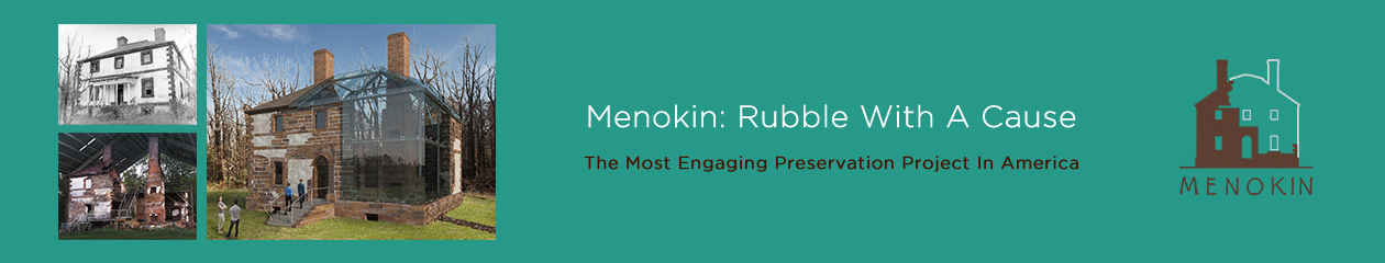
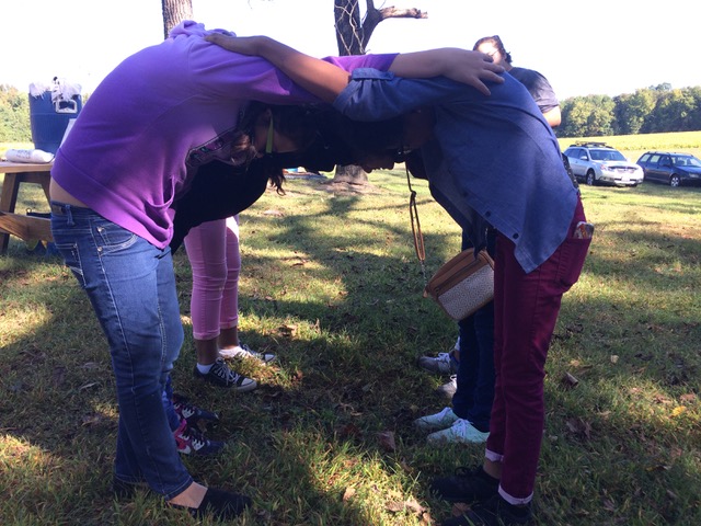
This month, students from Essex Intermediate visited Menokin to learn why cultural institutions like ours are part of the Rappahannock River Valley Watershed. This is more than a STEM program, and a state initiative to give every 6th grader a MWEE, “meaningful watershed educational experience” it’s STEAM: Science, Technology, Engineering, Arts, (or Architecture as we like to say) and Math. And at Menokin, we demonstrate these important ways of learning every day.
STEArchitectureM – Human StairsSTEArchitectureM – Human Arch
Students get to visit the site and have a real water experience in a canoe on Cat Point Creek; walk the trails and learn about this special habitat; take a Hard Hat Tour and learn about the cultural history of this property, and it’s relationship to where they live.
Heading out on Cat Point Creek.
Why is Menokin involved in a program about watersheds? Because our site has a history that goes back thousands of years. Did you know that, while our continents were forming, and waterways and mountains being created, that Menokin was always on high ground? People have lived here for a long time because of its rich natural resources, that have always made it a desirable place to live.
ScienceTArtM: Grinding soil pigments.ScienceTArtM: Painting with soils.
Our house is a couple of hundred years old, yet the high-ground of our landscape is thousands of years old and inhabited my many for thousands of years before English settlers ever arrived. Our house may be the largest artifact we have of recent cultures, but our ground is deeply embedded with the cultures of many before Captain John Smith ever arrived. Yet, he carried on the identity and heritage of the Rappahannock Tribe, by using their word for this special place, Menokin, which we still call it today, in the 21st century .
Menokin, a 500 acre classroom connecting the past to the present. Come visit for yourself, connect with your world, and be inspired.
Originally prepared in October 2012 and revised in November of 2013, this research conducted and prepared by C. Allan Brown is part of the The Menokin Glass House Project.
The report will be shared in a serial fashion with the intention of a weekly post as time allows.
PART I
The objective of this report is to provide an explication of how the landscape of Menokin has functioned historically as a setting for human habitation. The focus is “cultural” usages and meanings rather than “natural” conditions as wildlife habitat. To borrow the terminology of anthropological studies, the analysis centers on an examination of human pathways (movement through space in time) and activity areas (utilization of space in time). Eighteenth-century plantations in America were complex agricultural-production systems. Their organization reflected societal and individual attitudes. In the most refined examples, such as Menokin represents, they were also expressions of aesthetic and associational values.
Perhaps the most distinctive quality of the natural landscape of Virginia’s Northern Neck, the broader geographic setting between the Potomac and Rappahannock rivers, is the pattern of irregularly-shaped, small plateaus encompassed by shallow escarpments that occasionally approach true “cliffs” in character. In the vicinity of Menokin, the level (or nearly level) upper plateaus are typically quite modest in extent. By contrast, the tidewater landscape farther down the peninsula (as also along the lower James and York rivers) is usually flatter and more broadly expansive. Land, sea and sky begin to merge there. But in Menokin’s locale, discrete elevated pockets of land have been carved by numerous interconnected rivulets. The resulting dendritic pattern is clearly visible in satellite imagery of the immediate region (Fig. 1).
Figure 1
The generally wooded condition of the surrounding ravines has created nearly continuous bands of foliage that envelope each enclave. The density and verticality of the trees define compact spatial edges and frequently also limit long-distance views. Upon each plateau itself there is a prevailing sense of containment and seclusion. Those particular qualities also make the Menokin landscape quite different from the continuously rolling topography of the piedmont to the west, where the ground levels (and perspectives) constantly vary, and mountains are always on the horizon. It is evident that the natural landscape of Menokin (Fig. 2) has had significant implications for the development of its cultural landscapes.[1]
Figure 2
Menokin plantation takes its name from references to the Indian word associated with the stream which bounds the property along the southeast. As early as 1657/58 the name “Manakin” appears in local records in relation to that “Creek” or “Run” or “Swamp.”[2] (An upper branch sometimes was called “Muddy Run”; in recent years, the latter name also has been applied to the entire stream.) The current spelling of Menokin only became standard in the late 18th Century with the Lee family tenure. Prior to that, numerous transliterated variations may be found, ranging widely from “Monoaton” to “Monocon” to “Manoikin.” Mary R. Miller, in her very useful study of Place-Names of the Northern Neck of Virginia (1983), in attempting to distinguish between the variant spellings, nevertheless made some significant errors which have produced subsequent confusion.[3] It does appear however that the similar place-names of “Monascon,” “Monaskan” or “Menaskant” (thought to be a shortened form of “Monasukapanough”) identify an entirely separate locality on the border of present Richmond and Lancaster counties.[4]
The Algonquian meaning of “Menokin” is unknown today, according to most authorities on American Indian cultures.[5] Variations of that place-name today appear throughout the eastern seaboard. As unlikely as it may seem, modern authorities also believe that the Algonquian word bears no relation to the Monacan Indians who inhabited the upper James River region during the contact era, yet who spoke a separate Siouan language.[6] (Thus the similar name of the Huguenot settlement of “Manakin,” established in 1699 in what became Powhatan County near an abandoned Monacan Indian town, is considered to be merely coincidental.) It also should be mentioned that there was a “Manoakin” on the Eastern Shore of the Chesapeake Bay as early as 1663.[7] Clifford C. Presnall’s article on “The Menokin Mystery” in the Northern Neck of Virginia Historical Magazine (pp. 3020-3022) attempted to address the matter but ultimately circulated further misinformation.
Menokin’s somewhat strategic location at the confluence of two small streams (named “Rappahannock Creek”[8] and “Manakin [sic] Creek”[9] in the earliest records) and near the
Figure 3
main travel artery of the Rappahannock River (Fig. 3) was recognized as being highly suitable for occupation even in the prehistoric era. An abundance of early artifacts (stone flakes, pottery shards and fire-cracked rock) have been recorded by archaeologists investigating the plateau near the house ruins (Fig. 4).[10]
Figure 4
By the contact era with Europeans, the vicinity was occupied by the Rappahannock Indians (who evidently had resided in the broader region since about 1300 C.E.).[11]
The locality’s association with them is reflected in the site’s long-standing place names. Indeed, Capt. John Smith’s 1612 map of Virginia appears to locate the principal seat of the Rappahannocks (“Toppahanock”) in the general Menokin neighborhood (Fig. 5).[12] He reportedly first encountered them in December 1607 and then again in July 1608 (Fig. 6).[13]
Figure 5
Figure 6
One archaeologist has suggested that in the mid-seventeenth century (and perhaps earlier?), when there probably were only a few hundred Rappahannocks left, the
Figure 7Figure 8
chief “town of the Great Rappahannocks”[14] was situated along the southern edge of what became the Menokin estate (Fig. 7).[15] The particular promontory that he identified is one of the first to be encountered upstream along Rappahannock Creek and is slightly secluded yet affords a clear view to allow monitoring of movement on the nearby river.[16] It would seem to be an ideal defensive position. However, there appears to be disagreement among historians; a recent map of “Indians Towns” along the Rappahannock River (Fig. 8) does not include the Menokin location.[17] (In any case, compare the apparent discrepancies among the relative locations of “Toppahanock,” “Acquack” and “Nomanye”/”Nawmanay,” known today as “Nomini”.) This important subject needs to be more fully investigated in consultation with experts on Virginia’s indigenous people. Future archaeological excavations may clarify the matter.
[1] For the broader physical context, see John R. Wennersten, The Chesapeake: An Environmental Biography (Baltimore, 2000); Philip D. Curtin, Grace S. Brush and George W. Fisher, Discovering the Chesapeake: The History of an Ecosystem (Baltimore, 2001).
[5] See William Bright, Native American Placenames of the United States (Norman, OK, 2004), pp. 263, 278, 294.
[6] See Jeffrey L. Hantman, “Between Powhatan and Quirank: Reconstructing Monacan Culture and History in the Context of Jamestown,” American Anthropologist v. 92 (1990), pp. 676-690; Karenne Wood and Diane Shields, The Monacan Indians: Our Story (2000); Dennis B. Blanton and Julia A. King, eds., Indian and European Contact in Context: The Mid-Atlantic Region (Gainesville, FL, 2004), esp. pp. 22-26.
[7] See Virginia Magazine of History and Biography v. 19 (1911), pp. 173-180.
[8] Although the earliest documented name for the stream known today as Cat Point Creek is “Fleet’s Creek” (see Henry Fleete’s patent of 750 acres along that stream, dated 1 August 1652; Virginia Land Office Patent Book 3, p. 97), within a few years it was consistently known as “Rappahannock Creek” (see John Stephens’ patent of the original 1000 acres of the Menokin property, dated 13 March 1657/58; ibid., 4: 303). The name “Cat Point Creek” came into common usage only beginning in the nineteenth century. However “Cat Point, Rappahannock Creek” was familiarly known by the mid-eighteenth century; see, e.g., Virginia Gazette (Purdie& Dixon), 3 September 1772. The earliest record of “Catt [sic] Point” that I have seen dates to 5 February 1706; see Richmond County Deed Book 4, pp. 92a-93. There was a ferry across Rappahannock Creek situated at that location as early as 1686.
[9]John Stephens’ original 1000-acre patent of the Menokin property, on 13 March 1657/58, situates it as “upon Rappahannock River or Creek opposite to the land of Colo. Henry Fleete, bounding southwesterly upon the said creek which divides this land from the said Colo. Fleete’s land, southeasterly upon Manakin [sic] Creek being a branch of the said Rappahannock Creek;” Virginia Land Office Patent Book 4, p. 303. See also Camille Wells, “Menokin in Time: A Documentary Research Report” (1997) prepared for the Menokin Foundation; it is the most comprehensive history of the site that has been produced.
[10]See Thane H. Harpole, David A. Brown and Meredith Mahoney, “An Archaeological Survey of Menokin, Site 44RD35, Richmond County, Virginia” (June 2008), esp. figs. 2, 3, 10 and 23; Deanna Beacham, “Examples of Indigenous Cultural Landscapes in Virginia” (2011), pp. 15-17.
[11]U.S. Fish and Wildlife Service, “Rappahannock River Valley National Wildlife Refuge: Comprehensive Conservation Plan” (December 2009), section 3-6. See, also, James D. Rice, Nature and History in the Potomac Country: From Hunter-Gatherers to the Age of Jefferson (Baltimore, 2009); Edward DuBois Ragan, “Where the Water Ebbs and Flows: Place and Self Among the Rappahannock People, from the Emergence of their Community to its Seclusion in 1706” (PhD diss., Syracuse University, 2005); Stephen R. Potter, Commoners, Tribute, and Chiefs: The Development of Algonquian Culture in the Potomac Valley (Charlottesville, 1993).
[12]See Edward W. Haile, Virginia Discovered and Discribed [sic] by Captayn [sic] John Smith 1608 (Champlain, Virginia, 1995); Philip L. Barbour, ed., The Complete Works of Captain John Smith (1580-1631), 3 vols. (Chapel Hill, 1986). See, also, Helen C. Rountree, Wayne E. Clark, Kent Mountford, and Michael B. Barber, John Smith’s Chesapeake Voyages, 1607-1609 (Charlottesville, 2007); Susan Schmidt, Landfall Along the Chesapeake: In the Wake of Captain John Smith (Baltimore, 2006).
[13]Karenne Wood, ed., The Virginia Indian Heritage Trail, 3rd edition (Charlottesville, 2009), p. 42. See also Keith Egloff and Deborah Woodward, First People: The Early Indians of Virginia, 2nd edition (Charlottesville, 2006), esp. p. 76. The “Cat Point Creek and Vicinity” guide, published by the Friends of the Rappahannock (n.d.), identifies “Dancing Point” on the western shore of Menokin Bay (“location according to local legend”) as the site of the “King’s town” and the place where “in December of 1607, that the Rappahannocks first met the explorer Capt. John Smith.”’
[14]Stevan C. Pullins, “A Phase II Archaeological Evaluation of Site 44RD50 Associated with the Proposed Route 3 Project, Richmond and Westmoreland Counties, Virginia” (August 1992), p. 10. Note that elsewhere in that report (p. 9) the adjective “great” shifts place, modifying “town” (i.e., “Great Town of the Rappahannocks”). There is also a reference to a Rappahannock town along Rappahannock Creek (“Fleet’s Creek”) in a patent dated 8 October 1657: Virginia Land Office Patent Book 4, p. 185. Curiously, Wells’ comprehensive 1997 research report (“Menokin in Time,” op. cit.) makes no mention of Pullins’ 1992 report. See, also, Helen C. Rountree, Pocahontas’s People: The Powhatan Indians of Virginia through Four Centuries (Norman, Oklahoma, 1990), p. 118.
[15]Capt. Henry Fleete’s 1652 patent of land southwest of the present Menokin property was situated on the “north side of Rappahannock River, southwest of Great Rappahannock town where the Indians are at present seated 2 miles up Fleet’s Creek [i.e., Rappahannock or Cat Point Creek]” Virginia Land Office Patent Book 3, p. 97. See, also, Pullins, “Phase II Archaeological Evaluation,” pp. 11-12. John Stephens’ will, dated 5 March 1661, bequeathed the 1,000 acres of the Menokin property, “lying on Raa’ok. Creek, on the same side the Indians liveth on as per patent… ;” (Old) Rappahannock County Deed and Will Book, 1677-1682, Part I, pp. 66-68. See, also, Thomas Hoskins Warner, History of Old Rappahannock County, Virginia, 1656- 1692 (Tappahannock, 1965), pp. 36-37.
[16]It seems that the promontory has not been physically investigated by archaeologists; it was not examined during the survey conducted in 2008 by DATA Investigations, LLC. Aerial photographs indicate that as late as about 1950, that area of the plateau was open (now wooded). See, also, Douglas W. Sanford and Michael J. Klein, “An Archaeological Assessment of Richmond County, Virginia” (February 1994), pp. 91-95, 100. Not far from the Mount Airy millpond, a Rappahannock ossuary, dating from c. 1630-1660, was excavated just south of the Menokin property; see Potter, Commoners, Tribute and Chiefs, pp. 218-220.
[17]Figure 9 (uncredited) was found in the files of the Menokin Foundation. It may be related to the “Captain John Smith Chesapeake National Historic Trail” project. Also, Figure 6? For the uncertainty today of actual locations of the Indian towns, see Rountree, Powhatan, p. 12; Blanton & King, Contact, pp. 62-64, 69, 71.
The Menokin Foundation is pleased to announce that it has received $70,000 in grant money from the NPS to initiate planning and design for two public access points on Cat Point Creek at Menokin.
“We are excited to be able to begin the process of making Cat Point Creek more accessible to the public,” says Sarah Pope, Executive Director at Menokin, “And hope that the research performed during this planning phase will also help us to better understand the intricate story of the Menokin landscape.”
Looking up Cat Point Creek toward Menokin Bay.
The National Park Service (NPS) Chesapeake Bay Office announced on September 5, 2012 that the NPS is providing financial assistance to 21 partners and 24 projects with a combined financial commitment of $1,363,039. These projects with 21 partners in fiscal year 2012 address education, youth employment and stewardship programs, and public access and trail development in the Chesapeake Bay Gateways and Watertrails Network and along the Star-Spangled Banner National Historic Trail and the Captain John Smith Chesapeake National Historic Trail. Each project is leveraged through additional means such as matching funds, in-kind services, and volunteer hours.
In collaboration with many partners, the National Park Service works to expand public access to the Chesapeake Bay and tributary rivers, build visitor experiences along two national historic trails, develop teacher resources in line with state standards, and expand service and employment opportunities for youth. “Through partner engagement and participation, each of these projects has a positive impact in local communities,” said NPS Superintendent John Maounis. “Whether teaching the history of these places, introducing young people to possible career paths, or providing a new place to get to the water, these are investments in quality of life.”
The Chesapeake Bay Office of the National Park Service administers the Chesapeake Bay Gateways and Watertrails Network of partner sites, and also manages two of the nation’s nineteen national historic trails. Both trails are comprised of land and water routes accessible through partner sites, are in active stages of development, and offer opportunities for educators and students that are both virtual and place-based. Educational programming, training in stewardship and outdoor recreation skills, and youth employment opportunities all contribute to trail development.
Trail development and youth engagement projects also advance public access goals set through the Strategy for Protecting and Restoring the Chesapeake Bay Watershed, the federal response to President Obama’s Executive Order 13508. The strategy and subsequent draft public access plan call for the addition of 300 new sites where citizens can have a waterside experience, whether hiking, paddling, enjoying a picnic, or fishing.
Before the Menokin plantation was ever developed, this area along Cat Point Creek (also called Rappahannock Creek) was home to the Rappahannock Indian Tribe. In 1608, Capt. John Smith recorded 14 Rappahannock towns on the north side of the River and its tributaries. The general plantation site was referred to as “Menokin” by the Rappahannock, which likely translates to “He gives it to me” in the tribe’s Algonquian-based language. Francis Lightfoot Lee kept the name for his home. For more information on the Rappahannock Tribe, visit www.rappahannocktribe.org.